FarmIT 3000 - Adding Labels, Hedgerows, Rivers and Other Symbols
Farm IT Help - Adding Labels, Hedgerows, Rivers and Other Symbols
Adding Labels, Hedgerows, Rivers and Other Symbols
You may add labels, hedgerows, rivers and other symbols to your map to identify areas or buildings etc. Labels differ
from linked fields in that if you double click a field it will open the field
details whilst labels simply allow you to put text on your map. The other symbols provide exactly the required symbols for Farm
Stewardship including symbols for farm buildings, trees and archealogical features.
To add a label to your map first create or open the map, then right
click on the map to bring up the map menu. Select the 'Edit' option to change the mode
to edit mode.

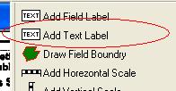
Right click again and select 'Add Label' from the popup edit menu
or select the add label option from the toolbox.


Now click on the map where you want the label to be placed. A label will
automatically be added to the map.
You may adjust the position of the label by clicking on it so it goes black
and either using the arrows on the number keypad on your keyboard, pressing 8
for up, 2 for down, 4 for left and 6 for right or dragging it
around with the mouse by keeping the left mouse button pressed down while
you move it around the screen.
You may now resize the label by clicking on it to turn it black and dragging
one of the eight small tabs that appear around the box with the left mouse
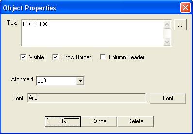
button pressed. Double click the label to set the font, its size and
colour or to change the text that appears on the label.

Once you are happy with the new label click 'OK' then use the map menu
(found by clicking with the right mouse button on the map) to save the map.
You may delete a field link or label
by double clicking on it in edit mode and clicking the 'Delete' button.
All the other objects may be added in a similar manner, hedgerows and rivers being
similar to field boundries, in that you click along the course of the hedgerow or
river and double click to finish.